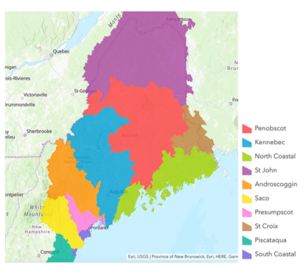
Zoom in to find your school on the map.
See how water travels from your location through your watershed to the ocean by searching your city or zip code here.

Androscoggin Watershed
The Androscoggin River lends its name to the entire watershed in western Maine. The Androscoggin River is Maine’s third-largest river.
Length: 164 miles (264 kilometers)
Drainage Area: 3,450 square miles (8.935 square kilometers) | 2,730 square miles (7,071 square kilometers) in Maine
Discharge at Mouth: 4.19 billion gallons (16 billion liters) per day
The Androscoggin drops more than 1,500 vertical feet in its journey from the Rangeley Lakes to Merrymeeting Bay.
More information about the Androscoggin Watershed can be found here.
Casco Bay Watershed
The Casco Bay watershed is home to the Fore, Piscataqua, Presumpscot and Royal Rivers. Sebago Lake, the largest body of water in Southern Maine, also feeds this watershed. Maine’s most populous city, Portland, falls within the Casco Bay Watershed.
More information about the Casco Bay Watershed can be found here.
Central Coastal Watershed
The Central coast watershed drains much less water then the other watersheds. Its lakes and rivers are smaller compared to their northern and southern cousins. Predominate rivers and lakes in the Central Coast watersheds are the Damariscotta, Medomak, Megunticook, Oyster, St George, and Sheepscot rivers, and the Damariscotta, St George and Sheepscot lakes.
More information about the Central Coastal Watershed can be found here.
Eastern Coastal Watershed
This watershed has some of the last relatively underdeveloped rivers in the state of Maine. The coastal shores of this watershed include Mount Desert Island, Jonesport, the Cutler Coast and Lubec. Notable rivers include the Union, East Machias and the Narraguagus.
More information about the Eastern Coastal Watershed can be found here.
Kennebec Watershed
The Kennebec River lends its name to the entire watershed in west-central Maine. The Kennebec River begins on Moosehead Lake, Maine’s largest freshwater lake, and falls 1,024 feet (312 meters) to enter the Atlantic Ocean.
Length: 170 miles (274 kilometers)
Drainage Area: 5,870 square miles (15,203 square kilometers) above Merrymeeting Bay
Discharge at Merrymeeting Bay: 5,893 million gallons (25 million liters) per day (avg.)
Notable tributaries into the Kennebec River are the Cobbosseecontee Lake, Indian Pond, the Dead River, Maranacook Lake, Messalonskee Lake, Moxie Pond, Pleasant pond, and the Sebasticook River.
More information about the Kennebec Watershed can be found here.
Penobscot Watershed
Penobscot River is a 109 miles (175 kilometers) long river in Maine. Together with its south and west branches, Penobscot River’s length increases to 240 miles (386 kilometers) making it the second-longest Maine river system. Its West Branch rises near Penobscot Lake on the Maine/Quebec border; the East Branch at East Branch Pond near the headwaters of the Allagash River. The main stem empties into Penobscot Bay near the town of Bucksport where it empties into the Atlantic Ocean.
Length: 240 miles (West Branch to Bucksport)
Drainage area: 8,570 square miles (22,196 square kilometers)
Discharge at mouth: 10.1 billion gallons (38 billion liters) per day (avg.)
More information about the Penobscot Watershed can be found here.
Piscataqua Watershed
The Piscataqua watershed is made up primarily of the Salmon Falls River, which forms the lower boundary between Maine and New Hampshire, and the Piscataqua River.
Drainage area: 1,495 miles (3,872 square kilometers)
Notable rivers in the Piscataqua watershed include: Kennebunk River, Oyster River, Piscatagua River, Salmon Falls River and the York River. This watershed extends into New Hampshire.
More information about the Piscataqua Watershed can be found here.
Saco Watershed
The Saco River lends its name to this watershed. The Saco River rises in the White Mountains of New Hampshire and runs about 120 miles to its mouth at Ferry Beach in the Atlantic ocean. The watershed drains about 1,703 square miles (4,411 square kilometers) of farmland and forests and was critical for the mill towns of Saco and Biddeford back in the industrial revolution.
Drainage area: 120 miles (193 kilometers)
More information about the Saco Watershed can be found here.
St. Croix Watershed
The St. Croix River forms the eastern boundary between Maine and Canada. It used to have some of the largest runs of anadromous fish in the state of Maine. Development for electric power has hindered the fish runs.
Length: 62 miles (100 kilometers)
Drainage area: 1,500 square miles (3,885 square kilometers)
More information about the St. Croix Watershed can be found here.
St. John Watershed
One of the largest river basins on the East Coast, the St. John drains over 21,000 square miles (54,390 square kilometers) of land. Its upper portions are some of the most remote stretches of river in all of New England. It encompasses the northern part of the state and some of the most remote areas of the northern woods in New England. The famous Allagash Wilderness Waterway flows in this watershed.
Length: 410 miles (660 kilometers)
Drainage Area: 21,230 square miles (54,485 square kilometers), and an additional 25,000 square miles (64,750 square kilometers) of the St John watershed is in New Brunswick Canada.
Discharge at Mouth: 25.5 billion gallons (97 billion liters) per day (avg.)
More information about the St. John Watershed can be found here.
